Monte Rosa, also known as the Monte Rosa Alps or the Monte Rosa Massif (in the Walser language, Gletscher), is, by size and importance, the second mountain group of the Alps and the highest in Switzerland.
It is located in the Pennine Alps and extends over Italian territory (in the municipalities of Alagna Valsesia, Ayas-Champoluc, Gressoney-La-Trinité, Gressoney-Saint-Jean, Macugnaga and Valtournenche) and Swiss territory (in the municipalities of Saas-Almagell and Zermatt).
Its name, contrary to what one might think, does not derive from the beautiful pink colour that tints the peaks at sunset, but from the word “rouja”, which in patois (the French-speaking dialect of the Aosta Valley) means glacier.
The “great glacier” was also known in the past as “Monboso”, as recorded by Leonardo da Vinci in one of his writings.
The Dufourspitze, at 4,634 metres, is the highest peak of the massif.
On 31 July 2005, the 150th anniversary of the first ascent, which took place on 1 August 1855, was celebrated.
Minister Alemanno and the Swiss Minister of Economy, Joseph Deiss, met for the unveiling of the commemorative plaque on the summit of the Dufourspitze, each arriving from their respective side of the mountain.
Already in the past, the high passes of the massif were crossed by the Walser populations who, in the 13th century, passed through the Colle del Lys to migrate from the Valais to the Lys Valley, where they created their settlements, giving rise to a new community that in the following years would extend to all the valleys surrounding Monte Rosa.
The ascent of the various peaks of the massif took place in the 19th century, generally starting from the Italian side, which was considered the easiest side. Below we list some of them:
Discover all the
ascents and traverses
on Monte Rosa
higher than 4,000 metres
Over 4,000 meters
Dufour peak
Elevation
4,634 m (15,203 ft) above sea level
Coordinates
45°55′00″N 7°52′00″E / 45.933333, 7.866667
First ascent date
1 August 1855
First ascent by
John Birbeck
Charles Hudson
Ulrich Lauener
Christopher Smyth
James G. Smyth
Edward Stephenson
Matthäus Zumtaugwald
Johannes Zumtaugwald
It is considered the highest peak of the Swiss Alps and the second highest of the entire Alps.
Furthermore, its east face above the municipality of Macugnaga is the highest in the Alps.
It was named in honour of Guillaume-Henri Dufour, general and cartographer of the Swiss army, under whose direction a series of military topographic maps were compiled, including the one concerning the Monte Rosa massif.
The mountain appears as a ridge where three main peaks can be clearly identified (from west to east): Punta Dufour – 4,634 m, Ostspitze – 4,632 m, Grenzgipfel – 4,618 m.
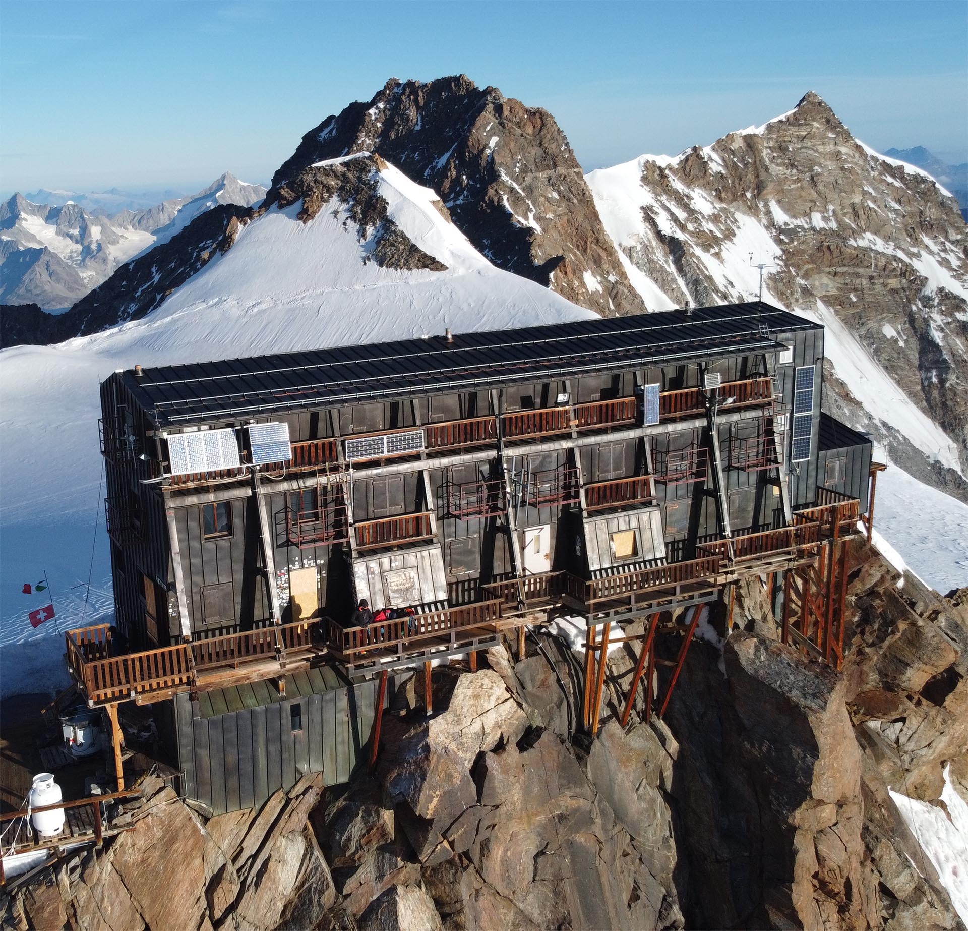
Normal Route from Capanna Regina Margherita: from the hut, descend to Colle Gnifetti (4,452 m) and climb the steep ridge to Punta Zumstein (4,563 m). From the summit of Punta Zumstein, descend to the saddle that separates the two peaks, the Grenzsattel (4,453 m). From the saddle begins the actual ascent to Punta Dufour via its south-east ridge, a mixed route of rock and snow graded AD.
Demanding ascent of approximately 3½ hours; some previous climbing experience and a good command of crampon use are required.
Rey Ridge from Capanna Regina Margherita, descend along the Grenz Glacier until passing the buttresses of Punta Zumstein, then climb up between long crevasses to the base of the ridge.
3–4 hours from the start of the route.
It includes sections up to grade IV. The descent follows the Italian normal route.
Nordend peak
Elevation
4.609 m s.l.m.
Coordinates
45°56′26″N 7°52′10″E / 45.940625, 7.869294
First ascent date
1861
First ascent by
T.F. and Edward
N. Buxton
J.J. Cowell
Michel Payot
Access to Nordend peak can be made starting from Capanna Regina Margherita via Zumstein peak and Dufour peak.
It is a very demanding route that follows sharp high-altitude ridges.
Coming from the Swiss Valais (from Zermatt), the ascent starts from the Monte Rosa Hütte (2,795 m).
From here, ascend the Monte Rosa Glacier (in German Monte Rosagletscher) up to the saddle known as Sella d’Argento (4,517 m), which separates Dufour peak from Nordend peak.
From Sella d’Argento, follow the entire ridge, keeping to the western slope due to the cornices; finally, a few rocks lead to the summit.
Also worth mentioning is the possible Santa Caterina Ridge (north-east), starting from Bivacco Città di Gallarate.
Zumstein peak
Elevation
4.563 m s.l.m.
Coordinates
45°55′55″N 7°52′17″E / 45.931944, 7.871389
First ascent date
1 August 1820
First ascent by
Joseph and Johann Niklaus Vincent
Joseph Zumstein
Molinatti
Castel and other guides
From Capanna Regina Margherita: descend to Colle Gnifetti (4,452 m) and climb to the left along the wide icy ridge of Zumstein peak.
Heading north-west, the ridge becomes noticeably narrower until it steepens sharply near a small crevasse.
After climbing the steep section, reach the final easy rocks and, via a last icy gully, reach the summit – 0.30 hours from Colle Gnifetti.
Gnifetti peak
Elevation
4.554 m s.l.m.
Coordinates
45°55′08″N 7°52′37″E / 45.927222, 7.876944
First ascent date
9 August 1842
First ascent by
Giovanni Gnifetti
Cristoforo Ferraris
Giacomo and Giovanni Giordani
Giuseppe Farinetti and two porters
It is possible to climb Gnifetti peak via the Italian normal route that passes through Colle del Lys (starting from Alagna Valsesia or from Gressoney-La-Trinité).
From Rifugio Gnifetti, ascend the Garstelet Glacier towards north-east, in the direction of Piramide Vincent, then head north over the gentle slopes of the Lys Glacier, keeping to the west of the base of Piramide Vincent.
After passing the rocky islet of Balmenhorn, reach a plateau at 4,150 m and traverse slightly to the right up to Colle del Lys (4,248 m).
Continue along the seracs at the northern base of Parrot peak. After passing the hollow of Colle Sesia, climb north along the head of the Grenz Glacier. Shortly before reaching the saddle of Colle Gnifetti (4,454 m), turn right and ascend from the north-west the final steep slope leading to the summit.
Difficulty F.
Time from Gnifetti hut: approximately 4–5 hours.
Signal Ridge: from Bivacco Resegotti, follow the ridge with alternating sections of snow and rock up to Colle Signal. From here, the ridge steepens and ends a few metres below the hut. It includes sections of grade IV. Approximately 6 hours from Bivacco Resegotti. The descent follows the normal route.
Lyskamm
Elevation
4.527 m s.l.m.
Coordinates
45°55′33″N 7°49′51″E / 45.925833, 7.830833
First ascent date
19 August 1861
First ascent by
William Edward Hall
Jean-Pierre Cachat
Josef-Marie Perren
J.F. Hardy, J.A. Hudson
C.H. Pilkington
A.C. Ramsay
T. Rennison, F. Sibson
R.M. Stephenson
Franz Lochmatter
Karl Herr and Stefan Zumtaugwald
It consists of two main summits: the Eastern Lyskamm, reaching 4,527 m, and the Western Lyskamm, reaching 4,481 m.
In addition, on the Italian side, opposite the two peaks, stands a third lower but particularly distinctive summit, known as Naso del Lyskamm (4,272 m).
It is possible to climb the Eastern summit from the Italian side starting from Giovanni Gnifetti Hut and reaching Col del Lys up to the plateau. From here, leave Roccia della Scoperta (4,178 m) on the right and follow the regular ridge leading to the shoulder. First cross a flat section, then a steeper part of the ridge, keeping a few metres on the northern side due to the cornices.
Difficulty PD+/AD-. 4–5 hours from Gnifetti Hut.
A fairly demanding but particularly striking route is the Lyskamm traverse. It can be completed from west to east or vice versa.
Sella Ridge to the Eastern Lyskamm: from Gnifetti Hut, reach Naso del Lyskamm and, after descending to Colle della Fronte, begin the climb. Once at the summit, descend to Colle del Lys along the normal route. It includes sections of grade 2+.
Difficulty: AD-. Approximately 5 hours from the hut.
Parrot peak
Elevation
4.432 m s.l.m.
Coordinates
45°55′10″N 7°52′10″E / 45.919444, 7.869444
Date of First Ascent
August 16, 1863
First ascent by
Reginald S. MacDonald
Florence Crauford Grove
Montagu Woodmass and William Edward Hall
With the guides Melchior Anderegg and Peter Perren.
As the mountain appears as a long and sharp ridge running west to east, it can be climbed either from the west via Colle del Lys or from the east via Colle Sesia (4,299 m), the saddle that separates it from nearby Gnifetti peak.
From Colle del Lys, turn right into the basin leading to Colle delle Piode. Climb the steep slope on the left to reach the ridge. Follow the narrow ridge to the summit.
Approximately 1 hour. Difficulty: PD+.
From Colle Sesia: about 100 m from the saddle, traverse to the right, climbing a steep section and passing to the left of a rock outcrop to reach the narrow ridge leading to the summit.
1½ hours. Difficulty: PD-.
Via degli Italiani: Starting from Bivacco Gugliermina (Valsesia), follow the ridge until reaching the Ghiacciaio delle Piode. From here, mixed terrain is encountered up to the terminal dome, which becomes steeper. It is a long mixed ascent with sections of grade II and III and slopes of 45°.
Difficulty: AD+. 5 hours from Bivacco Gugliermina.
Ludwigshoehe
Elevation
4.342 m s.l.m.
Coordinates
45°55′N 7°50′E / 45.92, 7.83
Date of First Ascent
1822
First ascent by
Luwig van Welden
From Gnifetti Hut, follow the obvious track leading to Colle del Lys. To reach the summit of Ludwigshöhe, there are three options:
1) from Colle Zurbriggen (4,272 m) via the south-west ridge, 20 minutes;
2) from the snowy basin near Colle del Lys (where the track to Margherita Hut passes), climbing to the left of the large crevasse that cuts across this slope and reaching the summit from the north-east, 40 minutes;
3) from Colle delle Piode (4,285 m) via the north-east ridge, 15 minutes.
Corno Nero
Elevation
4.322 m s.l.m.
Coordinates
45°54′54″N 7°51′43″E / 45.9149, 7.862
First ascent date
6 August 1875
First ascent by
From Colle Zurbriggen, it is possible to climb the nearby Schwarzhorn in approximately 40 minutes, via a short steep slope (max 45°) leading to a small saddle between the two summits and then left to the higher one, where the statue of the Madonna is located.
Approximate time from Indren: 3½–4 hours.
Vincent Pyramid
Elevation
4.215 m s.l.m.
Coordinates
45°54′29″N 7°51′43″E / 45.907958, 7.861876
First ascent date
5 August 1819
First ascent by
From Gnifetti Hut, follow the track to the left below the rocks leading onto the glacier until reaching a flat area. Climb the slope, which becomes progressively steeper, first heading north-east and then north, crossing various crevasses.
Continue towards Colle del Lys and, near 4,000 m, almost below the large rock of Balmenhorn, turn sharply right towards Col Vincent. Without reaching it, ascend the west–north-west face of Piramide Vincent, reaching the summit via a gentle snowy slope.
Difficulty: F. Approximately 2–3 hours from Gnifetti Hut.
Giordani peak
Elevation
4.046 m s.l.m.
Coordinates
45°54′21″N 7°52′05″E / 45.905808, 7.868142
First ascent date
First ascent by
Pietro Giordani and a small group of fellow villagers
The normal ascent to the summit from the Italian side starts from Punta Indren, from where the Indren Glacier is crossed towards Gnifetti Hut until reaching the glacier descending from the right. Climb it first keeping to the right and then in the centre to reach the flat snowy ridge and, to the right, the summit. Approximately 2 hours.
From the summit of Giordani peak, it is also possible, via a grade III alpine route, to reach the overlying Piramide Vincent.
The Soldato Ridge: Its distinctive name was given by William Martin Conway, who reached it in 1884 together with an Italian soldier, a border guard during the year of the cholera outbreak. The ascent can be made starting from Vigevano Hut (Col d’Olen). In this case, cross Stolemberg and reach the start of the ridge by traversing the Bors Glacier. Follow the entire ridge, bypassing its rocky features on the south-west snowfields. Easy mixed and rock ascent with sections up to grade 3.
Balmerhorn
Elevation
Coordinates
45°54′51″N 7°51′54″E / 45.914038, 7.864979
First ascent date
6 August 1875
First ascent by
Giovanni Mariotti
Andrea Pedretti
Simone Viguey
Welf Zaccaria
David Zaccaria
From Gnifetti Hut, follow the track to the left below the rocks leading onto the glacier until reaching a flat area. Climb the slope, which becomes progressively steeper, crossing various crevasses. Near 4,000 m, almost below the large rock of Balmenhorn, turn sharply right towards Colle Vincent (4,088 m), which separates Balmenhorn from Piramide Vincent, and shortly before reaching it, turn right again to tackle the final slope.
After retracing the summit dome back to the point of ascent, descend along the same slope heading straight towards the saddle below, which is reached in a few minutes. From there, continue by climbing the opposite side of the saddle, following the left diagonal until reaching the rocky base of Balmenhorn. A fixed rope and artificial steps allow easy access to the statue of Christ of the Peaks and the underlying Giordano bivouac.
Difficulty F.
Time from Gnifetti Hut: approximately 2 hours.
It is particularly famous because on its summit stand the Felice Giordano bivouac and the majestic statue of Christ of the Peaks.
The Christ of the Peaks (in the Walser language Der Christus vom Spétze) is a bronze statue depicting Jesus, placed on the summit of Mount Balmenhorn. During the Second World War, the sculptor Alfredo Bai was a partisan fighter. He vowed that, should the war end victoriously, he would erect a statue dedicated to Christ the Redeemer on a mountain in memory of those who had fallen in the war.
After the war, once the necessary funds had been raised, the sculptor created it in Turin in 11 separate pieces. It was then transported by the Alpini to the summit of the mountain.
Once placed on site, the statue, over four metres high, was inaugurated on 4 September 1955.
Emilio De Tomasi Via Ferrata at Cimalegna
Built in 2002, the Via Ferrata at Cimalegna, dedicated to the renowned guide Emilio De Tommasi, includes, among other features, the crossing of a Tibetan bridge (30 m), a walkway and, above all, offers a striking panoramic view.
From the lift station at Pianalunga, the start of the Via Ferrata can be reached in about 1 hour on foot. There are two possible routes: the blue route, which presents no particular difficulty and is also suitable for younger climbers, and the red route, longer and more demanding, with some exposed and vertical sections.
At the top, it is easy to continue towards Passo dei Salati to take the cable car down to Alagna, or head towards Vigevano Hut at Col d’Olen.
Duration: approximately 3:30 hours. Elevation gain: approximately 300 metres. Route length: 800 metres.
The use of a helmet, Via Ferrata set and harness is mandatory.
Recommended period: from May to October.
Alagna / Margherita without lifts
DAY 1 ALAGNA – PASTORE
After leaving the car at Wold, Acqua Bianca can be reached on foot along the paved road (15 km), where trail no. begins. 6. The easy and short route allows everyone to reach the hut.
Time from Alagna: 45–50 minutes.
Time from the Acqua Bianca parking area: 20 minutes.
As an alternative, from the hamlet of Sant’Antonio, where a small chapel stands.
After the church, about 50 m further on and before the carriage bridge, take trail no. 6 near a large boulder and reach the hut via a simple but fairly steep path with a long staircase.
Time from Alagna: 45–50 minutes.
Time from Sant’Antonio: 30 minutes.
DAY 2: PASTORE – VIGEVANO
From the meadow in front of the hut, trail no. 6 leads to Alpe Bors in about 45 minutes. After the small bridge crossing the Bors stream, the flat path gives way to stepped switchbacks leading to the group of houses of the panoramic Alpe Bors, among which stands Crespi Calderini Hut. After crossing the plateau in front of the hut, keeping slightly to the left, take trail no. 10, which continues in zigzag between small alders, reaching the next stage in about 1 hour.
The now decommissioned station of the Balma cableway, from which the Pisse waterfall can be admired in all its splendour. The route continues following the line of the old lift; it turns south towards a narrow gully, leading into the small valley that gently reaches the small lakes of Bocchetta delle Pisse.
Time from Pastore Hut: 2 hours.
At this point, it is possible to descend to Pianalunga and then climb up the Olen Valley (approximately 2 hours), or take the Emilio De Tommasi Via Ferrata at Cimalegna, from whose summit the historic Vigevano Hut can be reached (approximately 3½ hours).
DAY 3: VIGEVANO – GNIFETTI
From Vigevano Hut, reach Passo dei Salati, cross Stolemberg and arrive at Indren. Then cross the Indren Glacier, following the track to the left until reaching below a rocky bastion, passing through an area where several large crevasses are present.
At the end of the glacier, there are generally two tracks: the lower one leads to a path usually followed on descent, while the upper one leads to the “Via delle Rocce”, apparently more difficult but generally equipped to make the ascent safer (there are numerous fixed ropes and a wooden ladder).
Then follow a track across a snowy slope leading to some rock steps, which are overcome thanks to a metal ladder.
Time from Vigevano Hut: approximately 3 hours.
DAY 4: GNIFETTI – MARGHERITA
From Gnifetti Hut, rope up and ascend the Lys Glacier to Colle del Lys. From the saddle, the route descends sharply onto the Grenzgletscher to tackle a final slope leading to Colle Gnifetti (4,454 m). Keeping at a safe distance from some seracs on the right, from this last pass the track makes a wide semicircle and climbs the steep but short west face of Gnifetti peak, finally reaching the summit.
Time from Gnifetti Hut: approximately 4–5 hours.
Monte Rosa Tour
The Monterosa Tour develops around the Monte Rosa and Mischabel massifs, therefore crossing both Italian and Swiss territory. In particular, it follows for long stretches the paths that were used during the migratory movements of the Walser populations from one valley to another.
It consists of nine stages, generally starting and ending in Zermatt (Valais), but it can be adapted as desired, depending on personal needs and abilities.
Stage 1: departure: Zermatt – 1,616 m – arrival: Colle del Teodulo – 3,317 m
It is the most demanding stage of the tour due to the altitude reached and because part of the route crosses a glacier. An intermediate point is the alpine hut Gandegghütte.
Stage 2: departure: Colle del Teodulo – 3,317 m – arrival: Saint Jaques – 1,689 m
Starting from Colle del Teodulo, the stage first crosses the upper Valtournenche. It then passes into Val d’Ayas via the Colle Superiore delle Cime Bianche (2,980 m) and descends to Saint Jaques, a hamlet of Ayas.
Stage 3: departure: Saint Jaques – 1,689 m – arrival: Gressoney-La-Trinité – 1,637 m
The passage between the two valleys takes place via Colle Bettaforca (2,676 m).
Stage 4: departure: Gressoney-La-Trinité – 1,637 m – arrival: Alagna Valsesia – 1,191 m
The passage between the two valleys takes place via Col d’Olen (2,881 m).
Stage 5: departure: Alagna Valsesia – 1,191 m – arrival: Macugnaga – 1,327 m
The passage between the two valleys takes place via Passo del Turlo (2,738 m).
Stage 6: departure: Macugnaga – 1,327 m – arrival: Saas Fee – 1,772 m
The passage between the two valleys takes place via Passo del Monte Moro (2,868 m).
Stage 7: departure: Saas Fee – 1,772 m – arrival: Grächen – 1,619 m
The route follows the left side of the Saas Valley, skirting the Mischabel massif.
Stage 8: departure: Grächen – 1,619 m – arrival: Europahütte – 2,220 m
The route follows the right side of the valley, skirting the Mischabel massif.
Stage 9: Departure: Europahütte – 2,220 m | Arrival: Zermatt – 1,616 m
The route follows the right bank of the valley, once again skirting the Mischabel Massif.
Contacts: www.tmr-matterhorn.ch
Ski Mountaineering
Monte Rosa Haute Route
Day 1: take the lifts to Indren peak, then ascend with skins to Gnifetti Hut (3,647 m), dinner and overnight stay (2 hours).
Elevation gain: 400 m
Day 2: From Gnifetti Hut, ascend the Lys Glacier. Reach Colle del Lys and then Colle Sesia, where the climb to Margherita Hut on Gnifetti peak (4,554 m) begins. Descend via the Grenz Glacier to Monte Rosa Hut. (Approx. 6–7 hours)
Elevation gain: 1,100 m
Descent: 1,950 m
Day 3: Ascent to Silbersattel and Nordend peak (4,609 m). Return along the same route to Monte Rosa Hut. (Approx. 7–8 hours)
Elevation gain: 1,800 m
Descent: 1,800–2,900 m
Day 4: Descend to Zermatt, take the lifts up to Klein Matterhorn, ascend Breithorn West (4,184 m), and descend to Guide Val d’Ayas Hut. (Approx. 5–8 hours)
Elevation gain: 400 m
Descent: 1,700 m
Day 5: Ascent of Castore (4,228 m) on the west face, descent to Colle Felik and the West Lys Glacier to reach Naso del Lyskamm (4,100 m), Indren Peak, and return to Alagna. (Approx. 8–9 hours)
Elevation gain: 1,300 m
Descent: 1,500 m (3,500 m if returning all the way to Alagna)